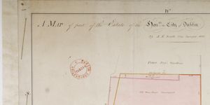
Map of a piece of Ground part of Sutor's Lane Situate on the back part of the South Side of Skinner Row
Plan of 2 lots, giving measurements and type of property on each. Adj. to 'Carbery's House' and 'Ram Ale House' on north; to passage from Skinner Row & City Wall on west; to holding of Richard Geering on south; & to former holding of Ald. French on east
CREATOR
David B. Worthington
DATE
1801-01-01 - 1801-12-31
LANGUAGE
ITEMS
1
INSTITUTION
Dublin City Library and Archive
PROGRESS
METADATA
Discover Similar Stories

Map of a Piece of Ground situate on the North Side of Hammond Lane part of the City Estate
1 Item
Annotation: 'On Moore's holding there is no Wall or Inclosier'

Map of a piece of Ground on the East side of Trinity Lane part of City Estate
1 Item
Plan of holding on Trinity Lane, with measurements. Adj. To Abraham Creaton's holding on northwest and to Andrew Concannon's on northeast; Robert Bouynge's holding is on southwest
Map of part of .. City Estate situate on the south side of Cook St.
1 Item
Plan of 2 holdings, frontage to Cook St. backing onto City Wall. One marked No. 94 in possession of Wm. Gargan; the other is 'Old Ware House'. Present measurements given and contrasted with bounds in original lease.