Map of part of .. City Estate situate on the south side of Cook St.
Plan of 2 holdings, frontage to Cook St. backing onto City Wall. One marked No. 94 in possession of Wm. Gargan; the other is 'Old Ware House'. Present measurements given and contrasted with bounds in original lease.
Show More
CREATOR
Arthur R. Neville
DATE
1812-01-01 - 1812-12-31
LANGUAGE
ITEMS
1
INSTITUTION
Dublin City Library and Archive
PROGRESS
START DATE
TRANSCRIBERS
CHARACTERS
LOCATIONS
ENRICHMENTS
METADATA
Discover Similar Stories

Map of part of .. City Estate ..situate on the south side of Cook St.
1 Item
Plan of No. 94, holding of Wm. Parry - for lease to Parry see Expired leases No. 1409 Jan 1700. Area of holding as shown in 'Old Map' is superimposed, and extensive annotations compare.

Map of a Building Lot of Ground on South Side of Cook St… City Estate
1 Item
Plan of holding 'No.94' with 'Old House' yard and open yard. Annotated: 'Nicholas Fleming'. Adj. City Wall on south.
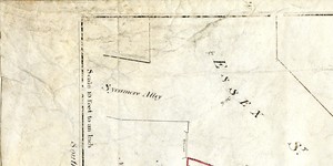
Map of part of City Estate on the south-east side of Essex St. demised to - '
1 Item
Holdings marked in red, part of which 'given' to Wide Streets Commissioners.