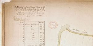
Map of a Piece of Ground situate on the North Side of Hammond Lane part of the City Estate
Annotation: 'On Moore's holding there is no Wall or Inclosier'
Show More
CREATOR
Thomas Mathews
DATE
1779-01-01 - 1779-12-31
LANGUAGE
ITEMS
1
INSTITUTION
Dublin City Library and Archive
PROGRESS
START DATE
TRANSCRIBERS
CHARACTERS
LOCATIONS
ENRICHMENTS
METADATA
Discover Similar Stories

Map of a piece of Ground on the East side of Trinity Lane part of City Estate
1 Item
Plan of holding on Trinity Lane, with measurements. Adj. To Abraham Creaton's holding on northwest and to Andrew Concannon's on northeast; Robert Bouynge's holding is on southwest
Map of a Piece of Ground Situate on the North Side of Bow Lane being part of … City Estate Surveyed and Divided into 11 Lotts
3 Items
1779 and 1781. Three copies of maps, one of which is annotated re inaccuracies in reference table

Map of a piece of ground on the East Side of Rosemary Lane, City Estate.
1 Item
For Merchants Quay scale at 20 ft:1 inch