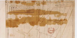
Map of the Little Green, Church Ground showing ground proposed for Sheriff's Jail
Ground plan of proposed Sheriff's Jail, frontage to Green Street
CREATOR
Thomas Mathews
DATE
1760-01-01 - 1769-12-31
LANGUAGE
ITEMS
1
INSTITUTION
Dublin City Library and Archive
PROGRESS
METADATA
Discover Similar Stories
Map of the Little Green, Church Ground
1 Item
Ornamentation: Fleur-de-Lis orientation with hand pointing north
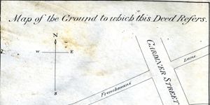
Map of the ground to which this deed refers
1 Item
Map showing location and dimensions of premises marked 'Commissioners of Revenue' on the north of Eden Quay and west side of Beresford Place. Includes details of surrounding area including location of Custom House, Lower Abbey Street, Gardiner Street, Frenchman's Lane and the River Liffey. Scale: 80 feet to an inch. Materials: Ink and water colours.
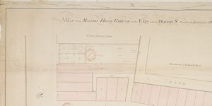
A Map of the Mansion House Ground on the East side of Dawson St. laid out for building
1 Item
Also shown: plan of a house adj. To St. Ann's Church Yard with garden, dressing room, kitchen, yard, coach horses, and 'stables for horses' Probably Northland House the house of the Lord Bishop of Derry and today the Royal Irish Academy