Map of the ground to which this deed refers
Map showing location and dimensions of premises marked 'Commissioners of Revenue' on the north of Eden Quay and west side of Beresford Place. Includes details of surrounding area including location of Custom House, Lower Abbey Street, Gardiner Street, Frenchman's Lane and the River Liffey. Scale: 80 feet to an inch. Materials: Ink and water colours.
CREATOR
Sherrard and Co.
DATE
1827-12-07 - 1827-12-07
LANGUAGE
eng
ITEMS
1
INSTITUTION
Dublin City Library and Archive
PROGRESS
METADATA
Discover Similar Stories
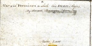
Map of the Premises to which this Deed Refers
1 Item
Map in two parts showing location and dimensions of premises on the north side of Eden Quay, south of a stable lane, bounded by property leased by the Commissioners of Wide Streets to Charles Pentland and William Cassin and premises on the east side of Werburgh Street, north of Werburgh Church and south of Castle Street. Scale: 40 feet to an inch. Materials: Ink and water colours.
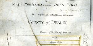
Map of premises to which this deed refers
1 Item
Map in three parts showing location and dimensions of several premises on the east side of Grangegorman Lane conveyed to the House of Industry by the Wide Streets Commission and indicating the ownership of such premises as established by an inquisition. Scale: 40 feet to an inch. Materials: Coloured ink.
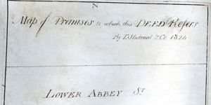
Map of Premises to which this Deed Refers
1 Item
Map showing location and dimensions of premises on the south side of Abbey Street Lower, also showing Harbour Court to the West and a stable lane to the south. Map indicates ownership by Wide Streets Commission and the Ballast Board of surrounding plots of land. Scale: 40 feet to an inch. Materials: Coloured ink.