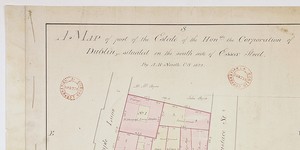
Map of part of City Estate on the south-east side of Essex St. demised to - '
Holdings marked in red, part of which 'given' to Wide Streets Commissioners.
CREATOR
Arthur R. Neville
DATE
1815-01-01 - 1815-12-31
LANGUAGE
ITEMS
1
INSTITUTION
Dublin City Library and Archive
PROGRESS
METADATA
Discover Similar Stories
Map of part of the City Estate on the south side of Essex Street
1 Item
Plan of 8 numbered holdings on south side of Essex Street with access to Temple Lane and Eustace Street. Giving boundary measurements and sometimes names of occupiers.
Map of part of .. City Estate situate on the south side of Cook St.
1 Item
Plan of 2 holdings, frontage to Cook St. backing onto City Wall. One marked No. 94 in possession of Wm. Gargan; the other is 'Old Ware House'. Present measurements given and contrasted with bounds in original lease.

Map of part of .. City Estate ..situate on the south side of Cook St.
1 Item
Plan of No. 94, holding of Wm. Parry - for lease to Parry see Expired leases No. 1409 Jan 1700. Area of holding as shown in 'Old Map' is superimposed, and extensive annotations compare.