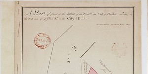
Map of part of the City Estate on the south side of Essex Street
Plan of 8 numbered holdings on south side of Essex Street with access to Temple Lane and Eustace Street. Giving boundary measurements and sometimes names of occupiers.
Show More
CREATOR
Arthur R. Neville
DATE
1822-01-01 - 1822-12-31
LANGUAGE
ITEMS
1
INSTITUTION
Dublin City Library and Archive
PROGRESS
START DATE
TRANSCRIBERS
CHARACTERS
LOCATIONS
ENRICHMENTS
METADATA
Discover Similar Stories
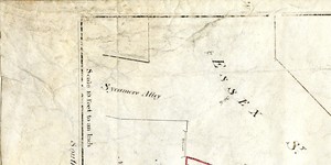
Map of part of the Estate of the city of Dublin situate on S.E. side of Essex Street
1 Item
Plan of part of City Estate, shaded pink, giving boundary measurements. Adj. to holding of Robert Dudley see AR/278 lease dated 27 April 1816 on southeast. Shows: 'Ground to be let into Essex Street'
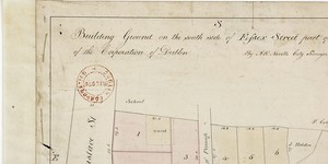
Building ground on south side of Essex Street, part of city Estate
1 Item
Plan of 6 lots, giving boundary measurements. Names of later occupiers pencilled in. Site of school shown on Eustace Street.
Map of part of City Estate on the south-east side of Essex St. demised to - '
1 Item
Holdings marked in red, part of which 'given' to Wide Streets Commissioners.