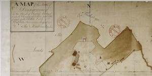
A Survey of the Lands of Donnycarney in the County of Dublin, Barony of Coolock and Parish of Clontarf, taken by Order of the Rt. Honble Lord Mayor, Sheriffs, Commons and Citizens of City of Dublin.
Elevation: Donnycarney House, surrounded by trees not Donnycarney House, part of Clontarf Golf Club; 3 houses on Strand-Artane rd. now Malahide rd. incl. 'Black Lyon'; 5 houses on the Strand now Fairviewroad incl. Yorkshire Grey,Red Lyon, & Mr. Carters's House
CREATOR
John Greene | Junior
DATE
1704-01-01 - 1704-12-31
LANGUAGE
ITEMS
1
INSTITUTION
Dublin City Library and Archive
PROGRESS
METADATA
Discover Similar Stories
A Map of the Lands of Donnycarney in the Parish of Clontarf, Barony of Coolock and County of Dublin. Estate of City of Dublin.
1 Item
Elevation: 17 Houses on or near The Strand, 19 houses along road leading from the Strand to Artane (present-day Malahide Road).

Map of the Lands of Donnycarney also part of lands of Drumcondra, Piperstown etc. in Barony of Coolock, County Dublin.
1 Item
This map plots same ground as C1/S1/130,131.
A Map of Clonturk in the Barony of Coolock and County of Dublin City Estate
1 Item
Lands of Clonturk from Drumcondra Bridge in west to Santry and lands of Domville in east.Divided in fields numbered 1-92; occupier given, also acreage and sometimes crop e.g. 'corn' 'garden' 'pasture and meadow'.