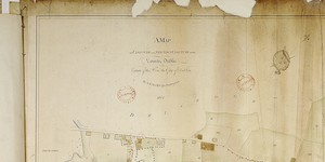
A Map of Clonturk in the Barony of Coolock and County of Dublin City Estate
Lands of Clonturk from Drumcondra Bridge in west to Santry and lands of Domville in east.Divided in fields numbered 1-92; occupier given, also acreage and sometimes crop e.g. 'corn' 'garden' 'pasture and meadow'.
Show More
CREATOR
Arthur R. Neville
DATE
1813-01-01 - 1813-12-31
LANGUAGE
ITEMS
1
INSTITUTION
Dublin City Library and Archive
PROGRESS
START DATE
TRANSCRIBERS
CHARACTERS
LOCATIONS
ENRICHMENTS
METADATA
Discover Similar Stories
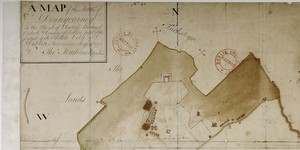
A Map of Clonturk and Newtown Clonturk in the County Dublin City Estate
2 Items
Map of lands of Clonturk from Drumcondra Bridge in west to Santry and lands of Sir Compton Domville in east. Clonturk lands divided into holdings, numbered consecutively 1-36.
A Map of the Lands of Donnycarney in the Parish of Clontarf, Barony of Coolock and County of Dublin. Estate of City of Dublin.
1 Item
Elevation: 17 Houses on or near The Strand, 19 houses along road leading from the Strand to Artane (present-day Malahide Road).

A Map of the Lands of Ballycullane and Grange Situate in the Barony of Castleknock and County of Dublin, City Estate.
3 Items
Compass Cross. Hands indicating direction of roads