Map of the Lands of Donnycarney also part of lands of Drumcondra, Piperstown etc. in Barony of Coolock, County Dublin.
This map plots same ground as C1/S1/130,131.
CREATOR
Thomas Mathews
DATE
1770-01-01 - 1770-12-31
LANGUAGE
ITEMS
1
INSTITUTION
Dublin City Library and Archive
PROGRESS
METADATA
Discover Similar Stories
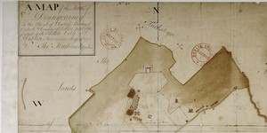
A Map of the Lands of Donnycarney in the Parish of Clontarf, Barony of Coolock and County of Dublin. Estate of City of Dublin.
1 Item
Elevation: 17 Houses on or near The Strand, 19 houses along road leading from the Strand to Artane (present-day Malahide Road).

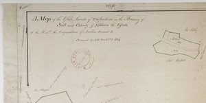
A Map of part of the Lands of Clonturke in the County of Dublin estate of the Corporation of the City of Dublin.
1 Item
Plan of 29 fields numbered consecutively 53-81, giving acreage and cultivation of each. Shading also indicates varying types of cultivation. Dublin-Swords-Drogheda road runs through fields which are adj. To Sir Compton Domville's estate.
A Map of the Glebe Lands of Taghadowe in the Barony of Salt and County of Kildare estate of City of Dublin
1 Item
Plan of four separate holdings: 1.Lady's Chapel and Church Yard, Garden and Field 2. Taghadowe Church Yard and Old Orchard, showing Round Tower; 3 Windgate Hill and field; 4 Land in dispute. Reference table lists acreage of each holding.