Map - Earlsfort Terrace, Stephen’s Green South and Harcourt Street
Showing plan of proposed new street (Clonmel Street) and design for converting the original lawn of Clonmel House into building ground. Scale: Not stated
CREATOR
Neville and Son
DATE
1837-10-01 - 1837-10-31
LANGUAGE
eng
ITEMS
1
INSTITUTION
Dublin City Library and Archive
PROGRESS
METADATA
Discover Similar Stories
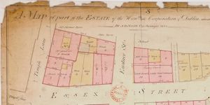
Map of City Estate . . situated on the north and south of Essex Street
1 Item
Plan of holdings with access to Essex Street; Temple Lane; Eustace St; New St and Wellington Quay giving the boundary measurements, names of occupiers and type of buildings.

Map of a House and Offices on the south side of Chatham Street, part of City Estate
1 Item
Plan of house 'No.9' with yard, privy and 'Back house'. Frontage to Chatham Street and access also by Tangier Lane. Adj. to holdings of Charles Leake, measurer, 7 Chatham Street to east and of J. Keegan on west.

Map of Ground on south of Exchequer Street and East and West of William Street. Estate of the City of Dublin. Laid out in Lots for Building
1 Item
Also shown: Willson's yard and Mr.Mallets with frontage to Exchequer street See AR/209 Premises in Exchequer St. to Robert Mallet, 17 Nov 1800