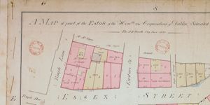
Map of City Estate . . situated on the north and south of Essex Street
Plan of holdings with access to Essex Street; Temple Lane; Eustace St; New St and Wellington Quay giving the boundary measurements, names of occupiers and type of buildings.
CREATOR
Arthur R. Neville
DATE
1822-01-01 - 1822-12-31
LANGUAGE
ITEMS
1
INSTITUTION
Dublin City Library and Archive
PROGRESS
METADATA
Discover Similar Stories
Map of part of the Estate of the City of Dublin Situated North and South of Essex St.
1 Item
Plan of holdings with access to Essex Street; Temple Lane; Eustace Street; New Street in continuation from Eustace Street and Wellington Quay giving the boundary measurements, names of occupiers and type of buildings.

Map of part of the City Estate on the south side of Essex Street
1 Item
Plan of 8 numbered holdings on south side of Essex Street with access to Temple Lane and Eustace Street. Giving boundary measurements and sometimes names of occupiers.
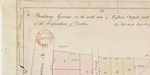
Building ground on south side of Essex Street, part of city Estate
1 Item
Plan of 6 lots, giving boundary measurements. Names of later occupiers pencilled in. Site of school shown on Eustace Street.