Map of a Piece or Parcel Ground Called the Pidgeon Park Situate at the South Side of James' St…in which is delineated the Sundry houses, Yards, Gardens etc contained in the same.
Annotated 'No. 46 Old Map Book Not inserted'.
Show More
CONTRIBUTOR
Thomas Mathews
DATE
1772-01-01 - 1772-12-31
LANGUAGE
ITEMS
1
INSTITUTION
Dublin City Library and Archive
PROGRESS
START DATE
TRANSCRIBERS
CHARACTERS
LOCATIONS
ENRICHMENTS
METADATA
Discover Similar Stories
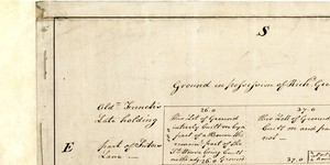
Map of a piece of Ground part of Sutor's Lane Situate on the back part of the South Side of Skinner Row
1 Item
Plan of 2 lots, giving measurements and type of property on each. Adj. to 'Carbery's House' and 'Ram Ale House' on north; to passage from Skinner Row & City Wall on west; to holding of Richard Geering on south; & to former holding of Ald. French on east
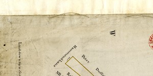
Map of a Piece of Ground situate on the North Side of Hammond Lane part of the City Estate
1 Item
Annotation: 'On Moore's holding there is no Wall or Inclosier'
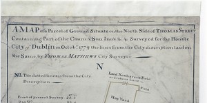
Map of a parcel of Ground Situate on the North Side of Thomas St.Containing Part of the Churn and Sun Inns…the lines of the City discription (sic) laid on same.
1 Item
Churn Inn yard and Sun Inn premises, frontage to Thomas Street and backing onto 'Lord Newhaven's Field or Croker's Lane'. Comparison with' Old Survey'