Map of the Red Mill etc. on part of the lands of Clonskeagh in the County of the City of Dublin demised by Will. McKasky Merct. To Thos, Saml. and James Baird
Land on west bank of river Dodder as far as 'Great Road' on north-west. Red Mill spanning Mill Race on river with enclosed Mill Pond. 'Slated Cabbins' on Great Road and 'Tenters' on river bank. Scale bar.
Show More
CREATOR
Arthur R. Neville
DATE
1824-01-01 - 1824-12-31
LANGUAGE
ITEMS
1
INSTITUTION
Dublin City Library and Archive
PROGRESS
START DATE
TRANSCRIBERS
CHARACTERS
LOCATIONS
ENRICHMENTS
METADATA
Discover Similar Stories
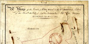
Map of the Lands of Ringwood in the County Dublin, estate of the City of Dublin, demised to Ald. Geo. Warner
1 Item
Ornamentation: Compass cross. Hands pointing directions.
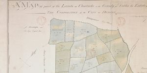
A Map of part of the Lands of Clonturke in the County of Dublin estate of the Corporation of the City of Dublin.
1 Item
Plan of 29 fields numbered consecutively 53-81, giving acreage and cultivation of each. Shading also indicates varying types of cultivation. Dublin-Swords-Drogheda road runs through fields which are adj. To Sir Compton Domville's estate.
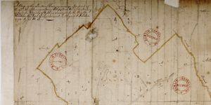
Map of the Lands of Donnycarney also part of lands of Drumcondra, Piperstown etc. in Barony of Coolock, County Dublin.
1 Item
This map plots same ground as C1/S1/130,131.