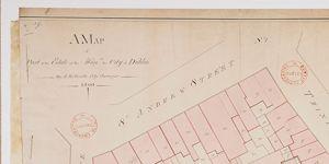
Map of part of Estate of City of Dublin
Plan of nine holdings north side of Essex St. from Old Custom House on west to Chas. Cotton's ware-house on east. Boundary measurements and names of occupiers.
CREATOR
Arthur R. Neville
DATE
1811-01-01 - 1811-12-31
LANGUAGE
ITEMS
1
INSTITUTION
Dublin City Library and Archive
PROGRESS
METADATA
Discover Similar Stories
Map of part of the Estate on Honble. City of Dublin
1 Item
An annotation compares length of College Green frontage with length as demised to Sir William Fownes in 1697 and 1699 see Expired leases No.601, 24 Apr 1696: No.590, Christmas 1697: No. 591 Christmas 1699. Also C1/S1/39. On reverse 'College Green Reference Only'.
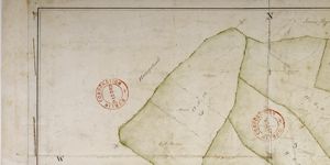
Map of part of lands of Clonturke, Estate of Corporation of Dublin
1 Item
Plan of 5 holdings to west of 'Great Road' Dublin-Swords-Drogheda. Acreage and cultivation given e.g. 'meadow' High pasture' etc. House and outbuildings in plan.
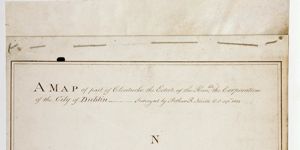
A Map of part of Clonturke Estate of the Corporation of the City of Dublin
1 Item
This map plots the same ground as C1/S1/124