A Map of part of Clonturke Estate of the Corporation of the City of Dublin
This map plots the same ground as C1/S1/124
Show More
CREATOR
Arthur R. Neville
DATE
1823-01-01 - 1823-12-31
LANGUAGE
ITEMS
1
INSTITUTION
Dublin City Library and Archive
PROGRESS
START DATE
TRANSCRIBERS
CHARACTERS
LOCATIONS
ENRICHMENTS
METADATA
Discover Similar Stories
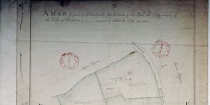
Map of part of Clonturke Estate of Honble the Corporation of City of Dubllin.
1 Item
Plan of three fields, to west of 'Great Road' Dublin-Swords-Drogheda. Acreage and cultivation given. Annotated: the present ditches are also drains.
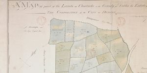
A Map of part of the Lands of Clonturke in the County of Dublin estate of the Corporation of the City of Dublin.
1 Item
Plan of 29 fields numbered consecutively 53-81, giving acreage and cultivation of each. Shading also indicates varying types of cultivation. Dublin-Swords-Drogheda road runs through fields which are adj. To Sir Compton Domville's estate.
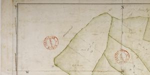
Map of part of lands of Clonturke, Estate of Corporation of Dublin
1 Item
Plan of 5 holdings to west of 'Great Road' Dublin-Swords-Drogheda. Acreage and cultivation given e.g. 'meadow' High pasture' etc. House and outbuildings in plan.