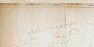
A Map of Newgate Market.
Plan of 81 numbered holdings in Market; reference table gives occupiers and measurements. Nos. 3-18 and 22-33 are adj. To City Wall. A comparison of this map with the two subsequent ones shows C1/S1/113 to be also a map of Newhall Market. The use of the name Newgate by Ramsey may spring from its proximity to the New Gate in the City Walls
CREATOR
James Ramsey
DATE
1731-01-01 - 1731-12-31
LANGUAGE
ITEMS
2
INSTITUTION
Dublin City Library and Archive
PROGRESS
METADATA
Discover Similar Stories
A Map of the several holdings (Terms subsisting) of the City Estate in Newhall Market.
1 Item
Plan of 8 holdings situated between Cook Street and the Corn Market. Holdings marked A-H: most contain stalls. Reference table gives names of occupiers, date on which lease granted and duration of lease. No orientation given.
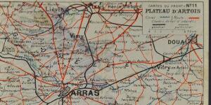
Map of Arras
1 Item
Front || Map of Arras, France – with pencil shading that perhaps indicated where the front line was.

Map of a Field at at Portobello designed for a Bason
1 Item
Plan of Mr.Dillon's Field,See Expired Leases No.1448. consisting of 2 acres near Latouche Bridge. Map signed by James Vance, Lord Mayor, John Carleton, City Treasurer and John Tudor, Sheriff, as Commissioners The Commissioners for Pipe Water.