Transcribe

Map of Arras

Front
Map of Arras, France – with pencil shading that perhaps indicated where the front line was.

Show More


CONTRIBUTOR

Sarah Offer

DATE

-

LANGUAGE

eng

ITEMS

1

INSTITUTION

Europeana 1914-1918

PROGRESS

START DATE
TRANSCRIBERS
CHARACTERS
LOCATIONS
ENRICHMENTS

Generating story statistics and calculating story completion status!

METADATA

Source

UGC

Contributor

europeana19141918:agent/063eecaf357f1215f9ed08fc73478dfe

Type

Other

Language

eng
English

Country

Europe

DataProvider

Europeana 1914-1918

Provider

Europeana 1914-1918

DatasetName

2020601_Ag_ErsterWeltkrieg_EU

Language

mul

Agent

Sarah Offer | europeana19141918:agent/063eecaf357f1215f9ed08fc73478dfe

Created

2019-09-11T08:29:32.316Z
2020-02-25T08:35:32.555Z
2020-02-25T08:35:32.556Z
2014-11-13 23:37:19 UTC

Provenance

INTERNET

Record ID

/2020601/https___1914_1918_europeana_eu_contributions_18172_attachments_206955

Discover Similar Stories
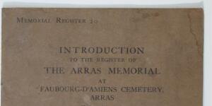


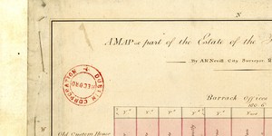
Map of part of Estate of City of Dublin

1 Item

Plan of nine holdings north side of Essex St. from Old Custom House on west to Chas. Cotton's ware-house on east. Boundary measurements and names of occupiers.

Go to:


A Map of Newgate Market.

2 Items

Plan of 81 numbered holdings in Market; reference table gives occupiers and measurements. Nos. 3-18 and 22-33 are adj. To City Wall. A comparison of this map with the two subsequent ones shows C1/S1/113 to be also a map of Newhall Market. The use of the name Newgate by Ramsey may spring from its proximity to the New Gate in the City Walls

Go to:


Arras Victim

2 Items

Thomas Hayes Towers

Go to: