Survey of ground in Walling Street and at the rere thereof in the City of Dublin sold by ... the Commissioners ... for making wide and convenient streets... to ... the Governors of the Hospital of King Charles II for ancient and maimed soldiers of the army
Map showing location and dimensions of 'New Military Road' running south-west to north east from Galway's Walk to the junction of Barrack Bridge, Usher's Island and Walling Street on the south bank of the River Liffey with surrounding lands noted as being let from Viscount Palmerstown to Mr Kelly. Scale: 80 feet to an inch. Materials: Ink and water colours. Seal of Alexander Worthington visible on scanned image.
CREATOR
Sherrard, D.H.
Sherrard, Thomas
DATE
1808-12-16 - 1808-12-16
LANGUAGE
eng
ITEMS
1
INSTITUTION
Dublin City Library and Archive
PROGRESS
METADATA
Discover Similar Stories
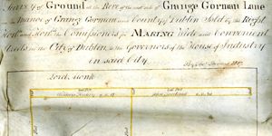
Survey of ground in the rere of the east side of Grange Gorman Lane in the Manor of Grange Gorman and County of Dublin sold by the Right Hon and Hon Commissioners for making Wide and Convenient Streets in the City of Dublin to the Governors of the House of
1 Item
Map showing location and dimensions of premises on Grange Gorman Lane indicating land already in the possession of the House of Industry and lands in the possession of Mrs Anne Maley, William Finlay and John Tankard, bounded by the lands of Lord Monk and Doctor Daly. Includes table showing quantity of land sold in acres, roods and perches. Scale: 80 feet to an inch.Materials: Coloured ink.
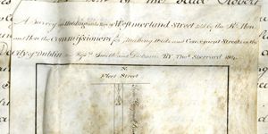
A survey of a holding at the rere of Westmorland Street sold by the Rt Hon and Hon the Commissioners for making wide and convenient streets in the City of Dublin to Messrs Smith and Dickson
1 Item
Map showing location and dimensions of premises at the back of properties on the east side of Westmoreland Street and properties on the south side of Fleet Street, with access to Fleet Street via a lane. Premises bounded on the north by the premises of Francis Tempest Brady, on the west by premises of the Wide Streets Commission, on the south by premises of Messrs Toole and on the east by the rear of Westmoreland Street. Scale: 20 feet to an inch. Materials: Coloured ink. Two seals at base of document included on scanned image,.
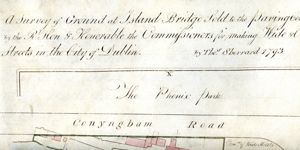
A Survey of ground at Island Bridge sold to the Paving Corporation by the Rt. Hon and Hon. the Commissioners for making Wide and Convenient Streets in the City of Dublin
1 Item
Map showing the location and dimensions of premises on the north side of the River Liffey near Islandbridge, between Conyngham Road on the north and the 'new bridge' on the east. Includes location of Phoenix Park to north of Conyngham Road and table showing total area of land sold in acres, roods and perches. Scale: 100 feet to an inch. Materials: Ink and water colours.