Survey of ground in the rere of the east side of Grange Gorman Lane in the Manor of Grange Gorman and County of Dublin sold by the Right Hon and Hon Commissioners for making Wide and Convenient Streets in the City of Dublin to the Governors of the House of
Map showing location and dimensions of premises on Grange Gorman Lane indicating land already in the possession of the House of Industry and lands in the possession of Mrs Anne Maley, William Finlay and John Tankard, bounded by the lands of Lord Monk and Doctor Daly. Includes table showing quantity of land sold in acres, roods and perches. Scale: 80 feet to an inch.Materials: Coloured ink.
CREATOR
Sherrard | Thomas
DATE
1807-10-30 - 1807-10-30
LANGUAGE
eng
ITEMS
1
INSTITUTION
Dublin City Library and Archive
PROGRESS
METADATA
Discover Similar Stories
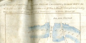
Survey of ground near Islandbridge in the county of Dublin sold to the Right Hon. and Hon. the Paving Corporation by the Right Hon. and Hon. the Commissioners for making Wide and Convenient Streets in the City of Dublin
1 Item
Map showing location and scale of premises marked numbers 66, 67 and 68, near Islandbridge on the north side of the River Liffey, directly north of Sarah Bridge, bounded on the north by the Phoenix Park and on the south by the "road from Dublin to Chapelizod". Scale: 100 feet to an inch. Materials: Ink and water colours.

A survey of ground near Islandbridge in the County of Dublin sold to the R. Hon. and Hon. the Paving Corporation by the R. Hon. and Hon. the Commissioners for Making Wide and Convenient Streets in the City of Dublin
1 Item
Map showing location and dimensions of premises marked numbers 73, 74 and 75 near Islandbridge, on the north side of the River Liffey, south of the 'Old Road from Chapelizod to Dublin' and bounded on the east by the 'old bridge'. Includes table listing details and size of each property in acres, roods and perches. Scale: 100 feet to an inch.Materials: Ink and water colour.

A Survey of an holding on the east side of Anglesea Street in the County and City of Dublin sold to Edward Croker by the Right Hon. And Hon. The Commissioners for making Wide and Convenient Streets in said city
1 Item
Map showing location and dimensions of 2 lots of property on the east side of Anglesea Street, numbered 32 and 33, bounded on the north by a passage and on the east and south by lands in the possession of John Scanlan and Andrew Caldwell respectively. Also shows land ownership by John Scanlan and Thomas Sherrard to the north of the passage way. Scale: 10 feet to an inch.Materials: Coloured ink.