Accoumt sic of the apprehending two persons supposed to be the D. of Monmouth and Sir Thomas Armstrong
CREATOR
#Name:31473
DATE
/
LANGUAGE
eng
ITEMS
2
INSTITUTION
National Library of Scotland
PROGRESS
METADATA
Discover Similar Stories
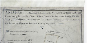
Map of a parcel of Ground Situate on the North Side of Thomas St.Containing Part of the Churn and Sun Inns…the lines of the City discription (sic) laid on same.
1 Item
Churn Inn yard and Sun Inn premises, frontage to Thomas Street and backing onto 'Lord Newhaven's Field or Croker's Lane'. Comparison with' Old Survey'
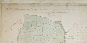
A Map of that part of the Lands of Clonturke the Property of the Corporation of Dublin, which remains to be left by them.
1 Item
Plan of 29 fields, numbered consecutively 53-81, with reference table listing occupier and acreage of each field. Pencilled annotation gives different acreage and occupier in some cases.
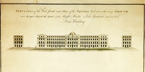
Elevation of the West front and Plan of the Square laid out on the rising Ground near Georges Church, the Estate of the Right Honble, Luke Gardiner and now to be Let for Building
1 Item
Elevation of the west front and plan of Mountjoy Square laid out on the rising ground, near George’s Church - the estate of the Right Hon. Luke Gardiner, and now (1787), to be let for building - Lord Mountjoy’s plan. General information: This engraving features the original plan for the development which was later to become known as Mountjoy Square. The area was surveyed and laid out in 1787 by Thomas Sherrard for the second Luke Gardiner, who later became Viscount Mountjoy. It was intended that the square should contain a central park, measuring 600 feet on each side. St. George’s Church in nearby Temple St, built by Sir John Eccles in 1714, was considered to be in need of a replacement. As this plan shows, it was intended to build the new St. Georges Church in the centre of the park. A note to this effect in the lower left hand corner (later cancelled) also states that the church yard would be retained at Temple St. In the event, the new St. George’s Church was built at its present location in Hardwicke Place. The central park was subsequently developed with an ash tree as its main feature instead of the church. The west front of the projected square is shown in elevation. This, if executed, would have been a major development, a four-storey building with frontage of almost 600 feet, surmounted by a central dome. The frontispiece was to include large pilasters and a triangular pediment, and was to have been ornamented with statues and urns. The architect is unknown, and is unlikely to have been Thomas Sherrard, who is credited merely with the survey and not with the elevation. The cost of erecting such a grandiose edifice must have been prohibitive and it was never built. In the end, the architecture of Mountjoy Square was similar to that employed elsewhere in Dublin, consisting of regular terraces with little ornamentation. The reason for the presence of this engraving among the archives of the Wide Street Commission is not clear, since that project was to be a private development by Luke Gardiner and was not submitted to the Commission for discussion or approval. The dual role of Thomas Sherrard as Secretary to the Commission as well as, in this instance, surveyor to Gardiner, may be a sufficient explanation. An engraving identical to this one, but without cancellation of the note in the lower left-hand corner, is in the National Library of Ireland. Surveyor: Thomas Sherrard, 60 Capel St. Scale: Not stated Size: 21" x 17¾" - 54 cms x 45 cms Paper (1 sheet, watermark ‘J. Kool’ with fleur-de-lis set in an oval frame under a coronet); engraving; mss. annotations.