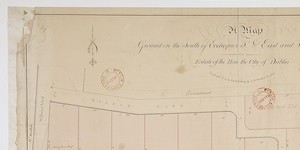
Elevation of the West front and Plan of the Square laid out on the rising Ground near Georges Church, the Estate of the Right Honble, Luke Gardiner and now to be Let for Building
Elevation of the west front and plan of Mountjoy Square laid out on the rising ground, near George’s Church - the estate of the Right Hon. Luke Gardiner, and now (1787), to be let for building - Lord Mountjoy’s plan. General information: This engraving features the original plan for the development which was later to become known as Mountjoy Square. The area was surveyed and laid out in 1787 by Thomas Sherrard for the second Luke Gardiner, who later became Viscount Mountjoy. It was intended that the square should contain a central park, measuring 600 feet on each side. St. George’s Church in nearby Temple St, built by Sir John Eccles in 1714, was considered to be in need of a replacement. As this plan shows, it was intended to build the new St. Georges Church in the centre of the park. A note to this effect in the lower left hand corner (later cancelled) also states that the church yard would be retained at Temple St. In the event, the new St. George’s Church was built at its present location in Hardwicke Place. The central park was subsequently developed with an ash tree as its main feature instead of the church. The west front of the projected square is shown in elevation. This, if executed, would have been a major development, a four-storey building with frontage of almost 600 feet, surmounted by a central dome. The frontispiece was to include large pilasters and a triangular pediment, and was to have been ornamented with statues and urns. The architect is unknown, and is unlikely to have been Thomas Sherrard, who is credited merely with the survey and not with the elevation. The cost of erecting such a grandiose edifice must have been prohibitive and it was never built. In the end, the architecture of Mountjoy Square was similar to that employed elsewhere in Dublin, consisting of regular terraces with little ornamentation. The reason for the presence of this engraving among the archives of the Wide Street Commission is not clear, since that project was to be a private development by Luke Gardiner and was not submitted to the Commission for discussion or approval. The dual role of Thomas Sherrard as Secretary to the Commission as well as, in this instance, surveyor to Gardiner, may be a sufficient explanation. An engraving identical to this one, but without cancellation of the note in the lower left-hand corner, is in the National Library of Ireland. Surveyor: Thomas Sherrard, 60 Capel St. Scale: Not stated Size: 21" x 17¾" - 54 cms x 45 cms Paper (1 sheet, watermark ‘J. Kool’ with fleur-de-lis set in an oval frame under a coronet); engraving; mss. annotations.
CREATOR
Sherrard | Thomas
DATE
1787-01-01 - 1787-12-31
LANGUAGE
eng
ITEMS
1
INSTITUTION
Dublin City Library and Archive
PROGRESS
METADATA
Discover Similar Stories
Map of Ground on south of Exchequer Street and East and West of William Street. Estate of the City of Dublin. Laid out in Lots for Building
1 Item
Also shown: Willson's yard and Mr.Mallets with frontage to Exchequer street See AR/209 Premises in Exchequer St. to Robert Mallet, 17 Nov 1800
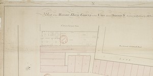
A Map of the Mansion House Ground on the East side of Dawson St. laid out for building
1 Item
Also shown: plan of a house adj. To St. Ann's Church Yard with garden, dressing room, kitchen, yard, coach horses, and 'stables for horses' Probably Northland House the house of the Lord Bishop of Derry and today the Royal Irish Academy
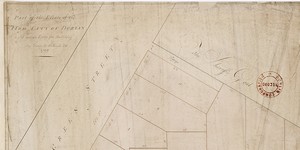
Part of the Estate of Hon. City of Dublin, Laid out in Lotts for building
1 Item
Ground plan of ten lots, bounded by Green Street. on south-east ; North King Street; Halston Street; and Sheriff's 'Goal' or Gaol on south-west