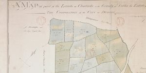
A Map of that part of the Lands of Clonturke the Property of the Corporation of Dublin, which remains to be left by them.
Plan of 29 fields, numbered consecutively 53-81, with reference table listing occupier and acreage of each field. Pencilled annotation gives different acreage and occupier in some cases.
Show More
CREATOR
Arthur R. Neville
DATE
/
LANGUAGE
ITEMS
1
INSTITUTION
Dublin City Library and Archive
PROGRESS
START DATE
TRANSCRIBERS
CHARACTERS
LOCATIONS
ENRICHMENTS
METADATA
Discover Similar Stories
A Map of part of the Lands of Clonturke in the County of Dublin estate of the Corporation of the City of Dublin.
1 Item
Plan of 29 fields numbered consecutively 53-81, giving acreage and cultivation of each. Shading also indicates varying types of cultivation. Dublin-Swords-Drogheda road runs through fields which are adj. To Sir Compton Domville's estate.
A Map of part of Clonturke Estate of the Corporation of the City of Dublin
1 Item
This map plots the same ground as C1/S1/124
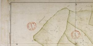
Map of part of lands of Clonturke, Estate of Corporation of Dublin
1 Item
Plan of 5 holdings to west of 'Great Road' Dublin-Swords-Drogheda. Acreage and cultivation given e.g. 'meadow' High pasture' etc. House and outbuildings in plan.