Map of a holding to which this deed refers sold to Mr James Murray
Map showing location and dimensions of premises marked number 10 on the east side of South Great Georges Street, bounded on the north by Susan McDonnough's holding, on the east by the rear of Dame Court and on the west by Dudley's holding. Scale: 20 feet to an inch.Materials: Ink and water colours.
CREATOR
Sherrard | Thomas
DATE
1812-12-23 - 1812-12-23
LANGUAGE
eng
ITEMS
1
INSTITUTION
Dublin City Library and Archive
PROGRESS
METADATA
Discover Similar Stories
Map of premises to which this deed refers
1 Item
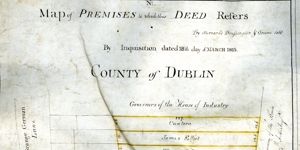
Map in three parts showing location and dimensions of several premises on the east side of Grangegorman Lane conveyed to the House of Industry by the Wide Streets Commission and indicating the ownership of such premises as established by an inquisition. Scale: 40 feet to an inch. Materials: Coloured ink.
Map of Premises to which this Deed Refers
1 Item
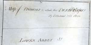
Map showing location and dimensions of premises on the south side of Abbey Street Lower, also showing Harbour Court to the West and a stable lane to the south. Map indicates ownership by Wide Streets Commission and the Ballast Board of surrounding plots of land. Scale: 40 feet to an inch. Materials: Coloured ink.
Map of Premises to Which this Deed Refers
1 Item
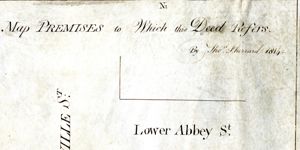
Map showing location and dimensions of premises marked numbers 10 and 11 on the east side of Sackville Street Lower and south side of Abbey Street Lower and the adjacent premises marked numbers 1 and 2 on the south side of Abbey Street Lower, bounded on the east by land in the possession of the Commissioners of Wide Streets and on the south by a stable lane and the property of Messrs Hawksley and Rutherford. Scale: 40 feet to an inch. Materials: Ink and water colour.