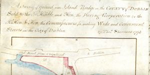
Survey of ground near Islandbridge in the county of Dublin sold to the Right Hon. and Hon. the Paving Corporation by the Right Hon. and Hon. the Commissioners for making Wide and Convenient Streets in the City of Dublin
Map showing location and scale of premises marked numbers 66, 67 and 68, near Islandbridge on the north side of the River Liffey, directly north of Sarah Bridge, bounded on the north by the Phoenix Park and on the south by the "road from Dublin to Chapelizod". Scale: 100 feet to an inch. Materials: Ink and water colours.
CREATOR
Sherrard | Thomas
DATE
1793-03-07 - 1793-03-07
LANGUAGE
eng
ITEMS
1
INSTITUTION
Dublin City Library and Archive
PROGRESS
METADATA
Discover Similar Stories
A survey of ground near Islandbridge in the County of Dublin sold to the R. Hon. and Hon. the Paving Corporation by the R. Hon. and Hon. the Commissioners for Making Wide and Convenient Streets in the City of Dublin
1 Item
Map showing location and dimensions of premises marked numbers 73, 74 and 75 near Islandbridge, on the north side of the River Liffey, south of the 'Old Road from Chapelizod to Dublin' and bounded on the east by the 'old bridge'. Includes table listing details and size of each property in acres, roods and perches. Scale: 100 feet to an inch.Materials: Ink and water colour.
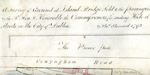
A Survey of ground at Island Bridge sold to the Paving Corporation by the Rt. Hon and Hon. the Commissioners for making Wide and Convenient Streets in the City of Dublin
1 Item
Map showing the location and dimensions of premises on the north side of the River Liffey near Islandbridge, between Conyngham Road on the north and the 'new bridge' on the east. Includes location of Phoenix Park to north of Conyngham Road and table showing total area of land sold in acres, roods and perches. Scale: 100 feet to an inch. Materials: Ink and water colours.
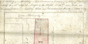
A survey of an holding in Pye Corner in the County of the City of Dublin sold to Mr Robert Magee by the Right Hon and Hon the Commissioners for Making Wide and Convenient Streets in said city.
1 Item
Map showing location and dimensions of premises marked number 2 on Pye Corner, a right angled street to the south west of Trinity Street, premises are bounded on the west by ground in the possession of George Pentland and on the north by an 'Alms house'. Scale: 20 feet to an inch. Materials: Ink and water colours. Two seals are visible on scanned image below the map.