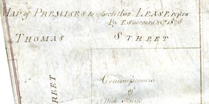
Map of Premises to which this Lease Refers
Map showing location and dimensions of premises on the south side of Wellington Quay, to the west of Ardill Row and the north of Temple Bar, bounded by the properties of Mr Young, Alderman Beresford, the Commissioners of Wide Streets and Mr Delamar. Scale: 40 feet to an inch. Materials: Coloured ink. (Same as WSC/Dis/217/2)
CREATOR
Sherrard and Co.
DATE
1815-11-29 - 1815-11-29
LANGUAGE
eng
ITEMS
1
INSTITUTION
Dublin City Library and Archive
PROGRESS
METADATA
Discover Similar Stories
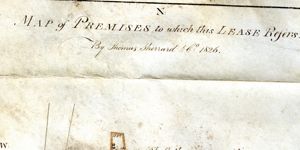
Map of Premises to which this Lease Refers
1 Item
Map showing location and dimensions of premises on the east side of Meath Street, south of the junction with Thomas Street, bounded on the north and south by grounds in the possession of the Wide Streets Commissioners and on the east by 'Walsh's Holding'. Scale: 20 feet to an inch. Materials: Coloured ink.
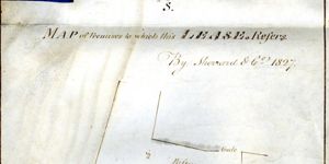
Map of Premises to which this Lease Refers
1 Item
Map showing location and dimensions of premises on the south side of Burgh Quay and the west of White's Lane, bounded on the south by a passage and the west by the Corn Exchange Tavern. Scale: 20 feet to an inch. Materials: Ink and water colour.
Map of Premises to which this Lease Refers
1 Item
Map showing location and dimensions of premises on the north side of Hanbury Lane, the east side of Thomas Court and the west side of Catherine's Court, bounded on the north by St Catherine's Church Yard. Scale: 40 feet to an inch. Materials: Ink and water colours. (Same as WSC/Dis/208)