Map of angle of Cavendish Row, Rutland Square and Great Britain Street - showing unsigned elevations and ground plan of Rotunda by Frederick Trench.
Plan of Cavendish St./Great Britain St. by Thomas Sherrard, with unsigned Elevations, 1787; and ground plan of Rotunda/New Assembly Rooms by Frederick Trench, 1787. General Information: The development of Cavendish Row commenced in 1786 and this ground plan and elevation was approved by the Wide Streets Commission on 9 March 1787. The ground plan for building lots both there and in Great Britain St. is by Thomas Sherrard. The elevations are unsigned, but were possibly by Frederick Trench, and amateur architect who was a member of the Commission. The elevation to Cavendish Row is for a terrace of four four-story houses, with rusticated quoins and rustication at ground level. Balconies are at all windows on the first floor. The elevation to Great Britain St. includes (on left) the return of the corner house on Cavendish Row. The houses in Great Britain St. are on a more modest scale and lack rustication. A note by the architect is as follows: ‘The Style of Buildings proposed here has long been in use on the Continent, and found uncommonly convenient in procuring Bed Chambers contiguous to Shops or the Apartments of Persons in Trade, unconnected with the Upper Floors’. This refers to the provision of a self-contained unit, consisting of shop at ground level and apartment at mezzanine level, and entirely separate residential quarters on the remaining upper floors. The ground plan of the Rotunda and New Assembly Rooms is by Frederick Trench. Most of the rooms survive, some in modified form; only the Card Room has disappeared. Scale: 10’ : 1” Size: 46 ½” x 32 ¼” - 118 ½ cms x 82 cms Paper (four sheets mounted onto canvas and bound with tape); ink; watercolours.
CREATOR
Trench | Frederick
DATE
1787-01-01 - 1787-12-31
LANGUAGE
eng
ITEMS
1
INSTITUTION
Dublin City Library and Archive
PROGRESS
METADATA
Discover Similar Stories

Map and elevation of a house at angle of Westmoreland Street/D’Olier Street
1 Item
House at angle of Westmoreland St./D’Olier St. Scale: Not stated

Plan of the stables of the Provost of Trinity College and of improvements of Nassau Street and Clare Street
1 Item
The widening of Nassau St. by the Wide Streets Commission in 1841 necessitated the purchase of part of the grounds pertaining to the Provost’s House, Trinity College, Dublin. A condition of sale was that the Provost’s stables and other outbuildings, which had to be demolished, should be rebuilt at the Commission’s expense. This series of five drawings, which details the re-building of the stables and other outbuildings and the erection of new gates and railings, was submitted to the Commission by Frederick Darley in July 1841. The drawings were approved but with minor modifications of a decorative nature which reduced costs by £315. The final costs amounted to £6,215-15s-6d. Scale: 10' 1''
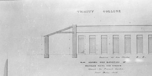
Plan of the stables of the Provost of Trinity College and of improvements of Nassau Street and Clare Street.
1 Item
Elevations for the proposed Stables, Coach House and Mews to be built at the Provost’s House, Trinity College Dublin, together with working drawings for iron railings and gates to be erected towards Nassau St. WSC/Maps/190/3 ‘Plans, sections and elevation of proposed Mews and Garden House in Provost’s Garden’ Neg No: 49 General Information : The widening of Nassau St. by the Wide Streets Commission in 1841 necessitated the purchase of part of the grounds pertaining to the Provost’s House, Trinity College, Dublin. A condition of sale was that the Provost’s stables and other outbuildings, which had to be demolished, should be rebuilt at the Commission’s expense. This series of five drawings, which details the re-building of the stables and other outbuildings and the erection of new gates and railings, was submitted to the Commission by Frederick Darley in July 1841. The drawings were approved but with minor modifications of a decorative nature which reduced costs by £315. The final costs amounted to £6,215-15s-6d. Scale: 10' : 1 Size: 18½" x 26½" - 46½ cms x 66½ cms Paper (1 sheet per drawing, each with watermark ‘J. Whatman, 1840'); ink; watercolours