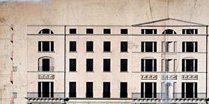
Map and elevation of a house at angle of Westmoreland Street/D’Olier Street
House at angle of Westmoreland St./D’Olier St. Scale: Not stated
CREATOR
Baker | Henry Aaron
DATE
1802-01-01 - 1802-12-31
LANGUAGE
eng
ITEMS
1
INSTITUTION
Dublin City Library and Archive
PROGRESS
METADATA
Discover Similar Stories
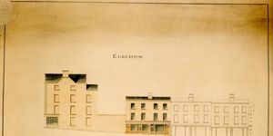
Elevation of Westmoreland Street from the Portico of the House of Lords to Fleet Street
1 Item
Elevation of Westmoreland Street, before opening Scale: Not stated

Elevation of Westmoreland Street (West side), extending from the Portico of the House of Lords to Fleet Street
1 Item
Including design for New Shops by A. Baker, Architect,1799. Approved 30 Jan 1800. General information: This is the fourth and final item in a series of designs for the west side of Westmoreland St. which was prepared for the Wide Streets Commission by Henry A. Baker during 1799 and 1800. This final design was approved by the Commission on 27 February 1800 and is the completed version of a sketch which had been approved by the Commission the previous January. (See WSC/Maps/195/1 b). The completed version follows the sketch in featuring an elevation for a terrace of seven five – storey houses with plain fenestration in all upper storeys. In each design, there is a range of shops at ground level with rectangular windows and separate business and residential entrances. However, whereas in the sketch the door-cases and windows are without adornment, in the completed version pilastered doorcases have been added, together with an ornamental frieze above. The buildings which were erected on the west side of Westmoreland St. correspond to this final design by Baker. Lots were set on 7 April 1800 with the stipulation that all stonework should be of Golden Hill or Glencullen granite. As building progressed, two separate minor modifications were introduced. On 10 July 1800, the Commission agreed that the ornamental frieze could be made of artificial rather than mountain granite, since this would be considerably less expensive. At its meeting of 17 July, the Commission further decided to add an architrave and cornice to the windows of the first, or drawing-room, floor corresponding to the Ballast Office which was then being built on the corner of Westmoreland St and Aston Quay. It was agreed that the architrave and cornice should be executed and erected at the Commission’s expense. On reverse: ‘Elevation of Westmoreland St.’ Architect: Henry A. Baker (Signature in red ink, faded) Copied by: Thomas Sherrard Scale: 5’ : 1” Size: 18.3/4” x 33.1/2”(Scale bar) - 47cms x 86cms Paper ( 2 sheets, backed onto canvas and bound with ribbon); ink; watercolours.
Elevation and plan of improvement (proposed) at Little Ship Street and Bride Street.
1 Item
This elevation and plan of proposed development at Little Ship St. features a terrace of six three-storey houses. The ground floor of each house contains a shop with back parlour, and residential accommodation is upstairs. Each house has a yard to the rear. The line of present and intended frontages is given, indicating that Little Ship St. is to be widened by distances varying between 16 and 23 feet. Architect Matthew Price submitted this plan to the Wide Streets Commission on behalf of the Bishop of Kildare. It was approved by the Commission on 3 July 1829. The houses have now been demolished, but a photograph exists showing part of the terrace. Scale: 10' : 7/8" Size: 30¼" x 21" - 76½ cms x 53¼ cms Paper (I sheet, no watermark); ink; watercolours