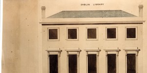
Elevation - Dublin Library, D’Olier Street.
This is the first of three elevations of the Dublin Library by George Papworth. The Dublin Library Society intended to erect their new premises on lots 5, 6 and 7 D’Olier St., which was then undergoing development by the Wide Streets Commission. This elevation was approved by the Commission at its meeting on 29 July 1818 and is signed by the Chairman of that meeting, Thomas Ellis. The elevation is for a three-storey building, which is five bays wide. A pillared portico forms the entrance, with a moulded lintel over the door. There is a railed area to the street, with two lamp standards. The windows are arched at ground level; rectangular at first floor level, with alternate triangular and conical pediments in the architraves; and square in the upper storey. The ground level was to be dressed with cut stone, but the Society had not then determined whether the remainder of the façade was to be built of the same material, or of red brick. The Wide Street Commission later decided to grant the Dublin Library Society a shorter frontage to D’olier St., and this necessitated the preparation of a fresh elevation by Papworth, which was submitted to the Commission in September 1818. (See WSC/Maps/120) On Reverse: ‘Elevation Dublin Library D’Olier St.’ Scale: Not stated Size: 18" x 24½" - 45½ cms x 62 cms Paper (1 sheet, no watermark); ink; watercolours
CONTRIBUTOR
Dublin City Library and Archive
Papworth, George
George Papworth
DATE
1818-04-01 - 1818-10-31
LANGUAGE
eng
ITEMS
1
INSTITUTION
Dublin City Library and Archive
PROGRESS
METADATA
Discover Similar Stories
Dublin Library Elevation and Plan
1 Item
General Information: This second elevation for the Dublin Library, again by George Papworth, was submitted to the Wide Streets Commission in September 1818. The proposed frontage of the Library to D’Olier St. had been shortened, and this had called for some modifications to Papworth's’ first elevation. Like the first, this second elevation is for a three-storey house, which is five bays wide, and this time with frontage of 56 feet. The façade as a whole has been simplified, with removal of the pediments above the first-storey windows. The pillared portico, railed area and lamp standards which were features of the first elevation have all been removed, and the entrance to the building is now shown on the left of the drawing. A ground plan which corresponds to this elevation was also prepared by Papworth. (See WSC/Maps/539). The elevation was approved by the Commission at its meeting on 9 September 1818, and it is signed by the Chairman of the meeting, Isaac Matthew D’Olier. A subsequent further reduction in the frontage, this time to 50 feet, meant that this second elevation had also to be set aside, and Papworth then prepared a third, which was submitted to the Commission in December 1818. (See WSC/Maps/121). Architect: George Papworth Scale: Not stated Size: 21½" x 25½" - 54 cms x 64cms Paper (1 sheet, no watermark); ink; watercolours

Ground plan for Dublin Library, D’Olier St.
1 Item
Ground plan for Dublin Library, D’Olier St, showing the building on a reduced scale Scale: Not stated

Map and elevation of a house at angle of Westmoreland Street/D’Olier Street
1 Item
House at angle of Westmoreland St./D’Olier St. Scale: Not stated