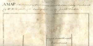
A Map of the ground in Parliament Street that was lately purchased by Mr William Smyth, surveyed in 1764 by Jonathan Barker
Map showing the location and dimensions of premises marked 'Mr William Smyth's Ground' on the east side of Parliament Street and the west side of Crane Lane, bounded on the north by Gorges Edmond Howard's ground and on the south by [Joshua] Leathly's ground. Scale: 20 feet to an inch. Materials: Coloured ink. Scanned image includes three seals.
CREATOR
Barker | Johnathan
DATE
1764-04-12 - 1764-04-12
LANGUAGE
eng
ITEMS
1
INSTITUTION
Dublin City Library and Archive
PROGRESS
METADATA
Discover Similar Stories
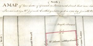
A map of two lots of ground in Parliament Street that was lately purchased by Mr Joshua Leathley. Surveyed in 1764 by Jonathan Barker
1 Item
Map showing location and dimensions of premises described as 'Mr Joshua Leathley's Ground' on the east side of Parliament Street and the west side of Crane Lane, bounded on the north by 'Smyth's Ground' and on the south by 'John Read's ground'. Scale: 20 feet to an inch. Materials: coloured ink. Three seals included in scanned image at base of map.
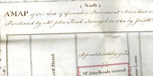
A map of one lot of ground in Parliament Street that was lately purchased by Mr John Read. Surveyed in 1764 by Jonathan Barker
1 Item
Map showing location and dimensions of premises described as 'Mr John Reads Ground' on the east side of Parliament Street and the west side of Crane Lane, bounded on the north by Jossuah Leathley's Ground and on the south by Gorges Edmond Howards Ground. Scale: 20 feet to an inch.Materials: Coloured ink.
A map of the ground in Parliament Street that was lately puchased by Mr William Smyth
1 Item
Map showing location and dimensions of premises on the east side of parliament street and the west side of Crane Lane labelled 'Mr William Smyth's Ground' and bounded on the north by Gorges Edmond Howard's ground and on the south by Joshua Leathly's ground. Scale: 20 feet to an inch. Materials: Coloured ink. Three seals also shown in scanned image.