Map of a Lott of Ground extending 370 feet from Church St. to Pudding Lane in the parish of St. Michan's and liberites of the city of Dublin belonging to Mrs. Bridget St. John alias Hadsor
Seven numbered plans with reference table: 1. Dwelling-house and 2. Warehouse and yard, tenure Christopher Fitz-Simons; 3. Yard; 4. Warehouse and 5. Yard, all forming encroachment by City of Dublin; 6. Back-house and 7 Dwelling-house, Mrs. St. John
CONTRIBUTOR
Johnathon Barker
DATE
1761-01-01 - 1761-12-31
LANGUAGE
ITEMS
1
INSTITUTION
Dublin City Library and Archive
PROGRESS
METADATA
Discover Similar Stories

Map of a piece of ground belonging to the Corporation of Dublin Scituate on the West Side of Church St. near Hangman (or Hammon) Lane extending from Church St. on the East to Pudding Lane on the West
1 Item
Plan of 'Still House' with frontage to Church Street, giving dimensions. Adjacent to holding of Edmund St. John on south and to 'Ball Yard' separated from latter by wall 2ft thick
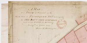
Map of a parcell of Ground on the South Side of Exchequer St. belonging to the City of Dublin laid out in Lotts for Building. This part of the then Exchequer St. is known today as Wicklow St.
1 Item
See Expired leases No. 470a lease to Christopher Johnston, 28 Apr 1704.See AR/209 Premises in Exchequer St. to Robert Mallet 17 Nov 1800.

Map of a Lot of Ground at rere of Lurgan St being part of the Estate of the Honble. City of Dublin demised to [blank]
1 Item
Holding leased to Abraham Lane in Dec 1818. See AR/194 with map attached, copy C1/S1/007