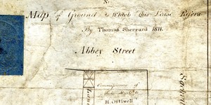
Map of Ground to which this Lease Refers
Map showing the location and dimensions of premises number 13 on the west side of Sackville Street. Scale: 10 feet to an inch. Materials: Coloured ink.
CONTRIBUTOR
Thomas Sherrard
Sherrard, Thomas
Dublin City Library and Archive
DATE
1811-01-01 - 1811-12-31
LANGUAGE
eng
ITEMS
1
INSTITUTION
Dublin City Library and Archive
PROGRESS
METADATA
Discover Similar Stories

Map of Ground to which this Lease Refers
1 Item
Map showing the location and dimensions of premises number 11 on the west side of Sackville Street. Scale: 10 feet to an inch. Materials: Coloured ink.
Map of Ground to which this Lease Refers
1 Item
Map showing the location and dimensions of premises number 12 on the west side of Sackville Street. Scale: 10 feet to an inch. Materials: Coloured ink.

Map to which this lease refers
1 Item
Simple map showing location and dimensions of premises marked number 37 on the north side of Fleet Street, bounded on the north and east by the rear of D'Olier Street and on the west by John Murphy's holding. Scale: 40 feet to an inch. Materials: Coloured ink.