Map of premises to which this annexed deed refers
Map showing location and dimensions of three premises on D'Olier Street; 'The Dublin Tavern' located on the north-east side of D'Olier and south side of Burgh Quay and two premises on the south-west side of D'Olier Street numbered 1 and 4. Possession of surrounding properties indicated with names including Bagnall, Harrick, Monsarrat, Manders, Evans, Connolly and the commissioners. Map also shows junction of Westmoreland Street, D'Olier Street, Burgh Quay. and Carlisle Bridge. Scale: 40 feet to an inch. Materials: Ink and water colours.
CONTRIBUTOR
Dublin City Library and Archive
Thomas Sherrard
Sherrard, Thomas
DATE
1814-04-29 - 1814-04-29
LANGUAGE
eng
ITEMS
1
INSTITUTION
Dublin City Library and Archive
PROGRESS
METADATA
Discover Similar Stories
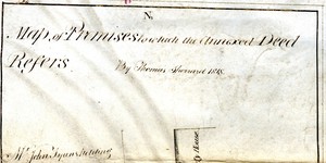
Map of Premises to which the Annexed Deed Refers
1 Item
Map showing location and dimensions of premises on the west side of Hawkins Street, bounded on the north by Mr John Fyan's holding, and on the west and south by the property of James Donovan Junior. Also shows a stable lane to the west and the former Dublin Society House on the east side of Hawkins Street. Note in the bottom right corner states conditions relating to the building of a passageway at the south of the premises. Scale: 40 feet to an inch. Materials: Coloured ink.
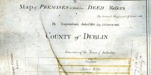
Map of premises to which this deed refers
1 Item
Map in three parts showing location and dimensions of several premises on the east side of Grangegorman Lane conveyed to the House of Industry by the Wide Streets Commission and indicating the ownership of such premises as established by an inquisition. Scale: 40 feet to an inch. Materials: Coloured ink.
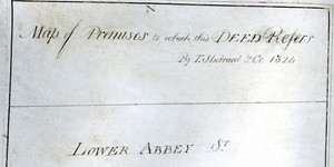
Map of Premises to which this Deed Refers
1 Item
Map showing location and dimensions of premises on the south side of Abbey Street Lower, also showing Harbour Court to the West and a stable lane to the south. Map indicates ownership by Wide Streets Commission and the Ballast Board of surrounding plots of land. Scale: 40 feet to an inch. Materials: Coloured ink.