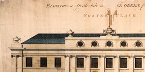
Elevation of two houses in Anglesea Street - corner of College Green.
Elevation of two houses in Anglesea St. corner of College Green Scale: Not stated
CREATOR
Johnston | Richard
DATE
/
LANGUAGE
eng
ITEMS
1
INSTITUTION
Dublin City Library and Archive
PROGRESS
METADATA
Discover Similar Stories
Elevation of North side of College Green from Anglesea Street
1 Item
Showing elevation of Daly’s Club House. General Information: The development of the Anglesea St/College Green/Foster Place nexus, incorporating the new Daly’s Club House, was carried out during 1787-9. The Wide Street Commission archives contain three drawings which relate to this development: an elevation to Foster Place(WSC/Maps/136/1); an elevation to College Green (WSC/Maps/445/2); and a section of a house adjoining Daly’s Club House on the north side of College Green (WSC/Maps/528). All three drawings are signed by architect Richard Johnston, and they were produced during March and April 1789. Daly’s Club was one of the more notorious Dublin 18th century gentlemen’s establishments. Originally situated at no. 2-3 Dame St, its clientele included nobility and members of Parliament. Negotiations with the Wide Streets Commission for a new site for a new Club House were opened by Daly’s in 1787 and continued into the following year. It was then agreed that the new Club House should form part of the proposed development in Anglesea St/ College Green/Foster Place, which would also include the offices of the Commissioners of Imprest Accounts. Daly’s Club House was to have frontage of 61 feet to College Green and 21 feet to Foster Place. Later in 1788, Daly’s also took a building lease of one of the plots adjoining the Club House and facing College Green. On 4 August 1788, the Wide Streets Commission wrote to the Duke of Leinster, as the representative of Daly’s, asking for an elevation of the intended Club House so that the facades of adjoining buildings could be made to correspond. The requested elevation was submitted to the Commission some time before March 1789, and unfortunately it has not survived, so that it is not possible to be certain who the architect was. The original College Green elevation of the Club House was copied by architect Richard Johnston at the Commission’s behest and integrated into Johnston’s overall design for the façade at College Green, which he submitted to the Commission on 20 March 1789. (See WSC/Maps/445/2). In spite of this, and although Johnston acted as clerk of works for Daly’s during the building of the Club House, scholarly opinion is reluctant to credit him with its design. Having approved of the elevation facing College Green, the Wide Streets Commission then directed Richard Johnston to produce an elevation of the west front of the block, facing Foster Place. In this instance, although Daly’s Club House also maintained some frontage onto Fosters Place, Johnston’s brief was to prepare a design to conform to the Imprest Accounts Offices. This elevation (See WSC/Maps/136/1) was submitted to the Commission on 3 April 1789, together with a ground plan of the development at College Green and Foster Place, by Thomas Sherrard, (now, WSC/Maps/136/2). Returning once more to the development facing College Green, Richard Johnston then prepared a section of one of the houses to be erected in that block, at the corner of College Green and Anglesea St. (See WSC/Maps/528). This section was approved by the Commission on 24 April 1789. This was the third and final drawing which Johnston prepared for the Wide Street Commission relating to the Anglesea St/ College Green/Foster Place development. He was not paid for this work until 5 February 1790, when he received the sum of £62-11s-3d. Scale: 6' 1''.
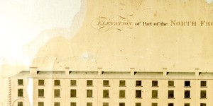
Elevation of Part of the North Front of College Green and Dame Street
1 Item
Showing College Green and Dame St. Scale: Not stated
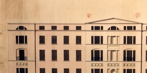
Elevation of houses on the west side of Westmorland Street
1 Item
General information: This is the first of two identical drawings for the west side of Westmoreland St. which were submitted to the Wide Streets Commission and approved on 1 August 1799. This first drawing is the original, by architect Henry Aaron Baker. The second drawing is an exact copy by Thomas Sherrard. (WSC/ Maps/ 194). For a more complete description of the drawing, and an analysis of its place in the sequence of designs for Westmoreland St. see WSC/ Maps/ 194. Architect: Henry A. Baker Scale: Not stated Size: 15 ½ x 25 ½ “ - 39 ½ cms x 65 cms Paper (1 sheet, no watermark); ink; watercolours