A plan of part of Dame Street laid out in Lotts for Buildings
Map of south side of Dame Street from Trinity Lane to George’s Lane, laid out in lotts for building with elevation at the top of map. By S. Sproule. Surveyed by Thomas Sherrard. (Marked: ‘No. 2’). General Information: This is the second in a series of two plans for the development of the south side of Dame St. which was prepared for the Wide Streets Commission during 1784 by architect Samuel Sproule, working from surveys by Thomas Sherrard. The first in this series which is marked ‘No. 1’ is a plan of part of the south side of Dame St. , from Palace St. to George’s Lane (now South Great George’s St.) laid out in lots for building. (See WSC/Maps/132). The second in the series, which is marked ‘No. 2’ is this plan of part of the south side of Dame St. from George’s Lane to Trinity St, laid out in lots for buildings to be erected. The plan features 18 building lots, numbered 17 to 34 inclusive. The building line is set back from the then line of Dame St. to facilitate the widening of the street. The elevation is for a terrace of 18 five- storey houses, with shop windows at ground level set into arches; all remaining fenestration is plain. The terrace is pierced in the centre by a lane running beneath an archway with a span of 10 feet, with ornamental keystone and nameplate above. This plan with elevation was submitted to the Wide Street Commission by Sproule on 16 July 1784 and was approved, with the recommendation that cut stone quoins, a cornice and a parapet should be added to no. 17 and no. 18 Dame Street. Sproule’s design was, however, soon to undergo a far more drastic revision. On 10 January 1785 Frederick Trench, a noted amateur architect, was appointed to the Wide Streets Commission. Almost immediately, Trench began to prepare his own design for the range of buildings to be erected on the south side of Dame Street. Trench’s design has not survived, but the minutes of the Commission state that it featured an amount of ornamental stone work, including rustic quoins, balustrades, pedestals, vases and arms. On 25 February 1785, Trench’s design was approved by the Commission and Sproule was ordered to revise his own plan and elevation accordingly. At a meeting held three days later, the Commission further agreed to meet the cost of the proposed ornamental stonework, and Sproule was asked to prepare an estimate of costs involved. Sproule submitted the required elevation to the Commission on 21 May 1785. This elevation was one executed by Aaron Baker on 17 May 1785, probably at Sproule’s request. Baker’s design was the one which was finally adopted and built by the Commission. (See WSC/Maps/342). Baker’s elevation closely follows Sproule’s original design, except that the central and end-of terrace blocks project slightly beyond the building range, and the central archway with lane has been removed. Trench’s ambitious plans for ornamental stonework had evidently been scrapped, as the only ornamentation in Baker’s design consists of rustic quoins on the projecting blocks. Although the estimate of costs of ornamental stonework requested by the Commission from Sproule has not survived, it would appear that Trench’s design had proved to be too expensive to execute Scale: 10' : 1" Size: 36½" x 115" - 93 cms x 156 cms Four sheets of paper, backed with canvas and bound with ribbon; plan on three sheets, with watermark; elevation on one sheet; ink; watercolours.
CREATOR
Sproule | Samuel
DATE
1784-01-01 - 1784-12-31
LANGUAGE
eng
ITEMS
1
INSTITUTION
Dublin City Library and Archive
PROGRESS
METADATA
Discover Similar Stories

Part of the Estate of Hon. City of Dublin, Laid out in Lotts for building
1 Item
Ground plan of ten lots, bounded by Green Street. on south-east ; North King Street; Halston Street; and Sheriff's 'Goal' or Gaol on south-west
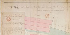
Map of Mansion House Ground in Dawson Street City Estate laid out for Building
2 Items
Plan of Mansion House with seven numbered lots adjoining three to the north and four on south. All lots with frontage to Dawson Street and measurements given. Also shown: Bowling Green to rear and east of Mansion House with beyond that St. Ann's Alms House.
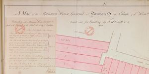
Map of Mansion House Ground in Dawson Street City Estate laid out for Building
2 Items
Plan of 29 numbered lots, 10 with frontage to Dawson Street and remainder to east on Bowling Green to rear of Mansion House. A note on the valuation of the lots indicates that some are on the site of Mansion House itself