A Map of Dolphin's Barn town together with the Inclosed City Ground etc.
Plan of the City Ground near Mill Stream. Also shown: Bason Lane, Dolphin's Barn Lane and road to Crumlin. Marked 'Old Map Book 43'
Show More
CONTRIBUTOR
Thomas Mathews
DATE
1771-01-01 - 1771-12-31
LANGUAGE
ITEMS
1
INSTITUTION
Dublin City Library and Archive
PROGRESS
START DATE
TRANSCRIBERS
CHARACTERS
LOCATIONS
ENRICHMENTS
METADATA
Discover Similar Stories

Map of a piece of ground on the East Side of Rosemary Lane, City Estate.
1 Item
For Merchants Quay scale at 20 ft:1 inch
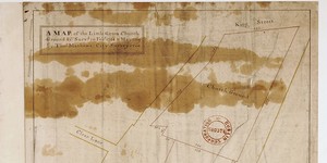
Map of the Little Green, Church Ground
1 Item
Ornamentation: Fleur-de-Lis orientation with hand pointing north
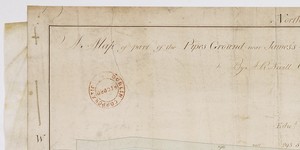
A Map of part of the Pipes Ground Near James Street part of the Estate of the City of Dublin
1 Item
Plan of City Water-Course running through garden and yard as far as Grand Canal Place. Adj. to holdings of Edward Stephens and Chris Flynn on north; and to Tyrell's Tannery on south.