Map of the Little Green, Church Ground
Ornamentation: Fleur-de-Lis orientation with hand pointing north
CONTRIBUTOR
Thomas Mathews
DATE
1768-01-01 - 1769-12-31
LANGUAGE
ITEMS
1
INSTITUTION
Dublin City Library and Archive
PROGRESS
METADATA
Discover Similar Stories
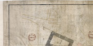
Map of the Little Green, Church Ground showing ground proposed for Sheriff's Jail
1 Item
Ground plan of proposed Sheriff's Jail, frontage to Green Street
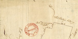
A Map of a Piece of Ground on the South Side of College Green, now in the possession of Thomas Blakeney, being part of the Estate of the Honble. City of Dublin
1 Item
A later lease to Blakeney refers to necessity for a survey of all premises by the City Surveyor before grant of renewal of lease. See Expired Leases No.639 dated 3 May 1770
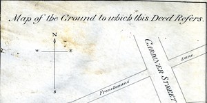
Map of the ground to which this deed refers
1 Item
Map showing location and dimensions of premises marked 'Commissioners of Revenue' on the north of Eden Quay and west side of Beresford Place. Includes details of surrounding area including location of Custom House, Lower Abbey Street, Gardiner Street, Frenchman's Lane and the River Liffey. Scale: 80 feet to an inch. Materials: Ink and water colours.